Guillaume le Testu was a French explorer, mapmaker, and
sometime pirate, back in the days of the Buccaneers.

He was born sometime around 1509–12, and became one of the
last pupils to be taught cartography at the famous school of Dieppe. Because of
his mapmaking skills, Le Testu took part in voyages of exploration all through
the Atlantic Ocean.
In 1550, Le Testu was commissioned by the king of France to
create a map of the Americas. It was a dangerous mission, because at the time,
knowledge of the landscape of the region was something of a military secret,
held by Spain and Portugal. Le Testu charted areas as far as Rio de Janeiro, when
he was attacked by the Portuguese and took heavy damage to his ship.
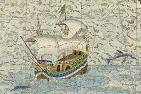
In 1555, Le Testu published a world atlas, and received an
award from the King for his work. The book contained 56 maps, based on charts
Le Testu had drawn by hand on his expeditions. This atlas was dedicated to his
mentor and patron Admiral Gaspard de Coligny, who had become leader of the
Huguenots three years earlier.
Interestingly enough, the work also contains a chart of
Australia, which Le Testu called “Java Major.” The area of the map near the as-yet
undiscovered continent contains drawings of what may be a black swan and a
cassowary, birds native to Australia. It is notated as follows:

The present Figure contains … La Grant Jave [Java Major], and La
Petite Jave [Java Minor] in which there are eight Kingdoms. The men of these
two Countries are Idolaters and wicked. Several manner of spices grow in these
two Regions, such as Nutmeg, Cloves, and other spices... This Land is part of
the so-called Terra Australis, to us Unknown, so that which is marked herein is
only from Imagination and uncertain opinion; for some say that La Grant Jave which is the eastern Coast
of it is the same land of which the western Coast forms the Strait of Magellan,
and that all of this land is joined together...
This Part is the same Land of the south called Austral,
which has never yet been discovered, for there is no account of anyone having
yet found it, and therefore nothing has been remarked of it but from
Imagination. I have not been able to describe any of its resources, and for this
reason I leave speaking further of it until more ample discovery has been made,
and as much as I have written and annoted names to several of its capes this
has only been to align the pieces depicted herein to the views of others and
also so that those who navigate there be on their guard when they are of
opinion that they are approaching the said Land...

Le Testu’s career was temporarily halted by the French Wars
of Religion. The mid-1500’s to the mid
1600’s were a time of civil and religious upheaval. In France, this took the form
of civil wars between the Huguenots (Protestant reformers) and Catholics. (Catholicism
being the official religion of France.) Le Testu, who had been mentored by a
member of the Huguenot cause, sided with the Huguenots. This was his entry into
piracy. He conducted privateering raids for two years, but was eventually
captured by the Catholics.
However, his service to France as a mapmaker came to his
rescue. After four years of imprisonment, he was released by order of King
Charles IX.
 |
| Francis Drake |
Le Testu went back to sea, perhaps aiming to improve his
maps. On March 23, 1573, he bumped into Sir Francis Drake near Cativá, Panama. Drake
shared news of the St. Bartholomew's Day massacre, an attack by the French King,
a Catholic, that killed many French Huguenot nobles. (Estimates range from
5,000 to 30,000 dead.) Upon learning of this, Le Testu offered to join Drake in
a raid against the (Catholic) Spanish.
Drake intended to attack the mule train carrying treasure to the city of
Nombre de Dios where galleons would
pick it up for transport to Spain.
Drake and Le Testu sailed their combined fleet to Panama. They
landed with their men just east of Nombre
de Dios. Le Testu had 70 men under his command while Drake himself led only
31. As their ships sailed off, with orders to return for them in four days, the
party headed inland to a spot south of the city, where they waited for the
Spanish mule train.

Soon after their arrival the pirates heard bells in the
distance – the bells on the Spanish pack mules. Scouts reported that the
caravan consisted of almost 200 mules, each carrying up to three hundred pounds
of treasure. Drake had chosen the spot for the ambush, believing the Spaniards
to be at their most vulnerable as they were nearing their destination, having
traveled through miles of jungle.
The attack was a complete success. Together Drake and Le
Testu captured nearly 30 tons of gold and silver. There was so much treasure
that the privateers were unable carry all the silver off and buried what
remained. (This may be one origin of the legends of buried treasure.)
However, Le Tetsu was seriously
wounded during the first assault. He was forced to rest by the roadside until
he was able to travel. Two of his men stayed at his side.
The rest of the party continued onward. to meet the scheduled
rendezvous with their fleet. But a Spanish fleet was waiting for them instead.
Drake escaped by constructing a raft and sailing to an island three leagues
offshore, where he contacted his own ships.
Once safely aboard with his crew, he sent a rescue party
back for La Testu. When Drake's men returned, they reported that the Frenchmen
and his companions had been caught by Spanish soldiers and executed. Le Testu
was beheaded. One of his men was tortured until he revealed the location of
most of the buried silver. Le Testu's head was taken back to Nombre de Dios where it was displayed in
the marketplace.
Fascinating entry, especially about Le Testu's mapping - I correct navigational charts and live in Java Major. ;)
ReplyDeleteAnyone notice anything odd on this atlas?).. besides the fact that Antarctica is accurately drawn when according to history, exploration of it only began about three centuries later…
ReplyDelete